About Coolock Village
The historic main street at the heart of Dublin 5 — a signposted village core on Main Street (R107) with verifiable official recognition.
About Coolock Village
The historic main street at the heart of Dublin 5 — a signposted village core on Main Street (R107) with verifiable official recognition.
What is Coolock Village?
Coolock Village is the historic village core of the wider Coolock area, centered on Main Street (R107). It is marked by official village signage, recognized by government agencies, and serves as the traditional center of the community.
Where is Coolock Village?
- Coordinates:53.388649°N, 6.201546°W
- Address:Main Street, Dublin 5
- Official:Sráidainm.ie
Planning & Development
Coolock Village's development is governed by the Dublin City Development Plan 2022–2028. The village core is designated as a Z3 – Neighbourhood Centres, which aims "To provide for and improve neighbourhood facilities and services."
Zoning Context (Mapset B)

- Mapset B (Zoning Maps)
Ref: Coolock Village Z1/Z3 zones - Z3 Neighbourhood Centre (Red hatch): The commercial village core along Main Street.
- Z1 Sustainable Residential Neighbourhoods (Yellow): Residential area supporting sustainable communities with local services and amenities.
- Z12 Institutional Land (Green): Former institutional lands adjacent to Chanel College.
- Z15 Community & Social Infrastructure (Blue): Chanel College grounds.
Key Development Objectives
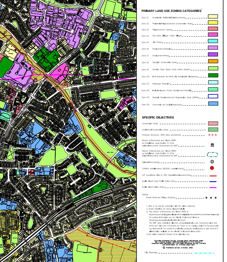
The map highlights the strategic zoning of Coolock Village as a vital service hub. The Z3 objective prioritizes local convenience and neighbourhood facilities. The Z1 designation supports sustainable residential development.
- CCUV1 – Support the role of village centres as hubs
- CCUV2 – Promote active street frontage and a mix of uses
- CCUV5 – Protect and enhance the vitality and viability of existing centres
- Read Chapter 7 (CCUV1–CCUV10)
Record of Monuments & Places (RMP)
Coolock Village contains recorded archaeological monuments — RMP DU015-076, an Early Christian Ecclesiastical Enclosure associated with St. Brendan of Clonfert. Archaeological excavations have uncovered the oval enclosure boundary, a stone cross, early medieval artefacts, and evidence of a holy well near St. John the Evangelist Church at Brookville.
A second record, RMP DU015-084, notes a chapel in Coolock village c. 1710 on the site of St. Brendan's Church.
Additional Planning Resources
Civic Data Dashboard
Civic Data
Live data from Dublin City Council and public data feeds for the Coolock Village area.
Planning applications
Dublin City Council planning activity near Coolock Village.
Bus arrivals
Nearby public transport arrivals from civic data providers.
Historic & Civic Records
Sráidainm.ie
The Streetnames Database of Ireland. Official record for "Coolock Village" (Sráidbhaile na Cúlóige).
National Archives Census
Searchable records from the 1901 and 1911 census, offering a window into the village's past demographic.
National Library of Ireland
Catalogue of books, maps, manuscripts, and photographs relating to Coolock's heritage.
Coolock Library
Your local resource for history, learning, and community events.
Archdiocese of Dublin
Coolock parish listing — uses "Coolock Village, Dublin 5" as the institutional address.
Frequently Asked Questions
Map Change Request
Requested label: Coolock Village
Irish name: Sráidbhaile na Cúlóige (Sráidainm.ie)
Coordinates: 53.38891°N, 6.19449°W
Scope: One-street village core on Main Street (R107), Dublin 5, Ireland
Copy one of the templates below and paste it into the appropriate map provider's feedback form.
All map provider feedback links:
Update Your Address
Include "Coolock Village" in your postal address.
Your Name
123 Main Street
Coolock Village
Dublin 5, D05 XXXX
Update name plates and business listings too.